Mexico City Sinking 2cm Monthly: NASA Tracks Crisis

NASA's advanced radar system reveals Mexico City's alarming subsidence rate of up to 2cm per month, threatening historic landmarks and infrastructure.
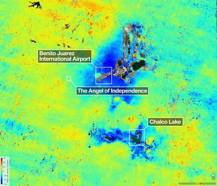
Mexico City faces an unprecedented geological crisis as NASA deploys cutting-edge technology to monitor the capital's accelerating subsidence. Using a powerful radar system, scientists are documenting what experts describe as one of the world's most severe cases of urban ground sinking, with measurements showing the city descends up to 2 centimeters monthly in certain areas. This alarming phenomenon, which has been unfolding for over a century, threatens not only the city's iconic architectural heritage but also its essential infrastructure and the wellbeing of its 9 million residents.
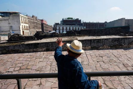
Visitors to Mexico City's iconic Zócalo plaza immediately notice something unsettling about the landscape. The magnificent cathedral, with its towering spires that once dominated the skyline, now appears to lean awkwardly to one side. Adjacent to it, the Metropolitan Sanctuary—an attached church of considerable historical significance—tilts noticeably in the opposite direction, creating an almost surreal architectural vista. The National Palace, seat of Mexico's government, also displays visible signs of structural stress, its once-straight lines now appearing distorted by the ground's relentless downward movement.
These architectural anomalies serve as visible reminders of a deeper geological problem affecting the entire metropolis. The subsidence issue stems from Mexico City's unique foundation—the metropolis was built on the bed of a drained lake, constructed upon layers of clay and sediment that continue to compact and settle. As the city's aquifers have been systematically extracted to supply water to the growing urban population, the ground beneath has progressively sunk, creating an ongoing crisis that demands urgent attention from city planners and environmental scientists.

The NASA monitoring system represents a significant advancement in understanding the scope and speed of Mexico City's descent. The space agency's sophisticated radar technology, which can detect ground movements with millimeter-level precision, has provided researchers with unprecedented data about the subsidence patterns occurring across different zones of the city. This geological monitoring effort, which experts hope will elevate public awareness about the crisis, reveals that certain neighborhoods are sinking far more rapidly than others, with some areas experiencing rates that far exceed the city-wide average.
Environmental scientists and urban planners have long recognized that Mexico City's subsidence problem is fundamentally linked to the city's unsustainable water consumption patterns. The metropolitan area, home to over 20 million people when surrounding suburbs are included, relies heavily on groundwater extraction from ancient aquifers that took thousands of years to form. As these aquifers are drained faster than nature can replenish them, the clay and sediment layers that make up the geological foundation gradually compact and lose volume, causing the entire city to sink toward the earth's surface at an accelerating pace.
The consequences of this urban subsidence extend far beyond aesthetic concerns about tilted buildings. Infrastructure damage accumulates rapidly as the ground shifts unpredictably—sewage systems designed with specific gradients no longer function properly, water pipes crack and rupture, and subway tunnels experience structural stress that threatens passenger safety. Additionally, the city's drainage systems become increasingly compromised, making the area more vulnerable to severe flooding during the rainy season when the city's ability to manage excess water becomes critically important.
The Mexico City sinking problem has become more pronounced in recent decades as rapid urbanization has accelerated both population growth and water demand. The city's expansion has placed unprecedented strain on already depleted aquifer systems, forcing engineers to pump groundwater from deeper and deeper levels. This intensified extraction has dramatically increased the rate of subsidence compared to historical patterns, turning what was once a gradual geological process into a crisis that now demands immediate intervention and comprehensive urban water management reform.
Scientists studying the subsidence phenomenon have identified specific neighborhoods and districts where the problem is most severe. The Iztapalapa and Gustavo A. Madero boroughs, among Mexico City's most densely populated areas, have experienced some of the highest subsidence rates recorded in the entire metropolis. In these neighborhoods, the ground has sunk by more than 40 centimeters over the past two decades, disrupting building foundations, damaging water infrastructure, and creating environmental hazards that directly impact residents' quality of life and safety.
The NASA research initiative comes at a critical moment in Mexico City's history, as local government officials grapple with how to manage competing urban demands while addressing an existential geological threat. The space agency's data collection efforts focus on creating detailed maps of subsidence patterns, which can then inform more strategic decisions about water management, infrastructure reinforcement, and urban development planning. By providing precise measurements of where and how quickly the ground is sinking, NASA's monitoring contributes essential scientific evidence to policy discussions about the city's sustainable future.

Addressing Mexico City's subsidence crisis requires a multifaceted approach that tackles both immediate infrastructure challenges and long-term water sustainability issues. City planners are exploring options including the development of alternative water sources such as rainwater harvesting and wastewater recycling, the restoration of natural springs and aquifer recharge zones, and the implementation of stricter water conservation policies across residential and industrial sectors. These initiatives, if successfully implemented, could potentially stabilize or even reverse the subsidence trend over the coming decades.
International attention to Mexico City's crisis has grown as the severity of the problem becomes increasingly undeniable. Other major cities around the world facing similar subsidence issues—including Jakarta, Bangkok, and New Orleans—are watching closely to see what solutions Mexico City's scientists and engineers develop. The geological challenges facing the Mexican capital thus carry implications that extend beyond national borders, offering lessons and warnings for urban centers globally that depend on groundwater extraction to sustain their rapidly growing populations.
The role of NASA's advanced monitoring capabilities in documenting Mexico City's subsidence underscores how space-based technology can contribute crucial insights to understanding and managing terrestrial environmental challenges. As climate change intensifies water scarcity pressures worldwide, and as more cities struggle to balance rapid urbanization with environmental sustainability, the tools and data that NASA provides become increasingly valuable. The agency's commitment to tracking Mexico City's descent demonstrates how scientific innovation and international cooperation can work together to illuminate critical challenges facing modern urban societies.
The future trajectory of Mexico City's subsidence problem will depend largely on the effectiveness of policy interventions implemented over the next several years. If current water extraction patterns continue unchanged, experts warn that some parts of the city could sink by an additional meter or more over the next twenty years, creating catastrophic consequences for infrastructure, public safety, and the city's historical heritage. Conversely, if comprehensive water management reforms are successfully implemented, the rate of subsidence could potentially be slowed dramatically, buying time for longer-term solutions to be developed and deployed across the metropolitan region.
Source: The Guardian


