Alaska's Colossal Megatsunami Ranks Second Largest Ever

Scientists discover tiny earthquakes triggered a catastrophic landslide that created Alaska's second-largest megatsunami. New research reveals stunning details about this geological disaster.
A groundbreaking scientific investigation has unveiled the mechanisms behind one of the most devastating natural disasters in recorded history: Alaska's colossal megatsunami that ranks as the second largest ever documented. Researchers have meticulously analyzed seismic data, geological evidence, and eyewitness accounts to piece together how this catastrophic event unfolded, revealing a complex chain of geological processes that culminated in an enormous wave of destruction.
The newly published analysis demonstrates that the triggering mechanism for this Alaska megatsunami was far more nuanced than initially understood. Rather than a single massive earthquake generating the destructive wave, the research indicates that a series of relatively small earthquakes initiated a devastating landslide that subsequently displaced an enormous volume of water. This discovery has significant implications for how scientists understand and predict similar events in tectonically active regions around the world.
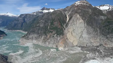
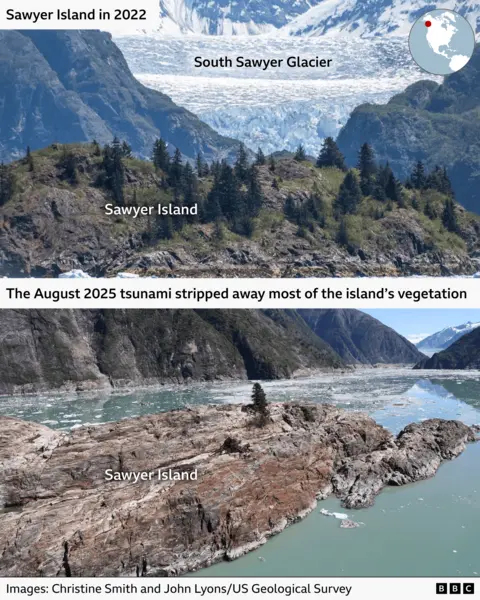
The landslide that triggered the megatsunami involved millions of tons of rock and soil cascading into a confined body of water, creating a sudden displacement that propagated outward as a massive wave. The specific geology of the region, combined with the accumulated stress from tectonic activity, created ideal conditions for this catastrophic failure. Scientists examining the aftermath found evidence of the original rock materials scattered across a wide area, providing crucial clues about the event's magnitude and mechanics.
Understanding the relationship between the small earthquakes and the resulting megatsunami has required sophisticated modeling and analysis of historical seismic records. Researchers utilized advanced computer simulations to reconstruct the sequence of events, accounting for local geological conditions, water dynamics, and the propagation characteristics of the resulting wave. These models provided unprecedented insights into how relatively minor seismic activity could unleash such a catastrophic force, challenging previous assumptions about megatsunami formation.
The timing and location of these preliminary earthquakes proved critical to triggering the cascade of events. Scientists discovered that the small seismic movements destabilized a massive accumulation of loose rock and sediment that had been precariously positioned on steep slopes above the water. The combination of gravitational stress and the mechanical disturbance from the earthquakes proved sufficient to overcome the natural barriers holding this material in place, initiating the catastrophic failure.
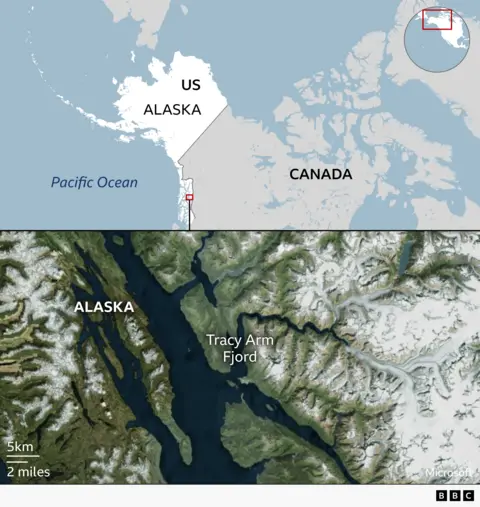
Historical records and geological evidence have allowed researchers to determine that this Alaska megatsunami occurred in a region with a complex tectonic history. The area experiences ongoing crustal deformation and stress accumulation, creating an environment where landslides represent a persistent hazard. The specific event in question represents an extreme case of this ongoing geological process, demonstrating how accumulated stress can suddenly release in catastrophic fashion.
The magnitude of the resulting wave astonished researchers examining the geological record. Wave heights reaching thousands of feet inundated surrounding areas, with evidence of the water's destructive power preserved in the landscape for centuries. The sheer volume of water displaced by the falling rock and soil created a phenomenon that defies imagination, yet the physical evidence tells an undeniable story of nature's raw power.
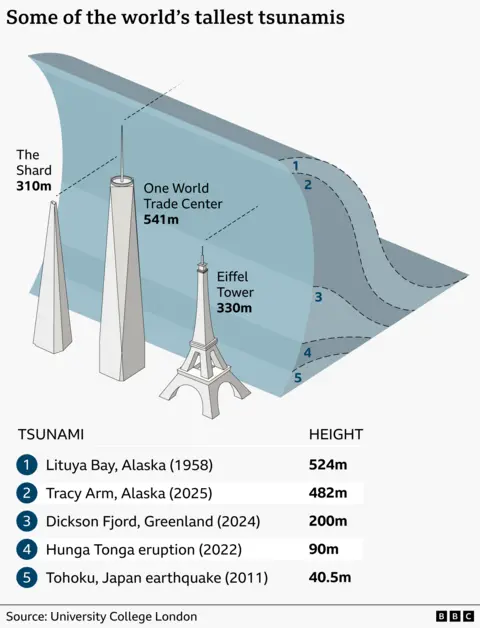
Comparing this event to other recorded megatsunamis provides crucial context for understanding its significance. As the second largest megatsunami ever documented, it ranks below only one other recorded event in terms of wave height and impact. This elevated ranking underscores the extreme nature of the geological processes that were set in motion by the initial small earthquakes and subsequent landslide. Scientists studying these rare events gain invaluable insights into Earth's dynamic geological systems.
The implications of this research extend far beyond academic understanding. Coastal regions worldwide that share similar geological characteristics may face comparable hazards. By understanding how small earthquakes can trigger catastrophic landslides and megatsunamis, scientists can better assess risks and develop improved early warning systems. This knowledge proves invaluable for communities in tectonically active areas where such disasters pose genuine threats to human safety and infrastructure.
Modern seismic monitoring networks have dramatically improved our ability to detect and analyze these events. The instruments in place today can record the subtle movements and energy releases that precede major geological failures. Researchers have utilized data from both historical events and contemporary monitoring systems to construct a comprehensive understanding of the processes leading to megatsunami formation. This technological capability represents a significant advancement in our geological knowledge.
The research team employed multiple methodologies to validate their findings, including detailed geological surveys, computer modeling, seismic analysis, and examination of historical records. This multifaceted approach provided robust evidence supporting the proposed mechanism of the megatsunami's formation. Scientists remain confident in their conclusions, though they acknowledge that future discoveries may refine current understanding of these extraordinary natural phenomena.
For communities living in regions vulnerable to similar events, this scientific analysis carries profound importance. Understanding how geological hazards develop and progress enables better preparation and risk mitigation strategies. Governments and local authorities can use this knowledge to improve building codes, develop evacuation plans, and invest in monitoring infrastructure that could save lives in future events. The research represents not merely academic advancement but practical knowledge with real-world safety implications.
The continued study of megatsunamis and their triggers remains an active area of geological research. Scientists worldwide are examining other potential sites where similar catastrophic events might occur, seeking to identify patterns and precursor signals. This global research effort aims to develop more sophisticated prediction capabilities and expand our understanding of Earth's most dramatic geological processes. The Alaska megatsunami serves as a crucial case study in this ongoing scientific endeavor.
Source: BBC News


